Quite a while ago farms transitioned from a single machine working a field, be it self-propelled or tractor and implement combination, to multiple machines working simultaneously and sometimes in tandem. Electronics on the machines and data gathering have become commonplace as well, all in an effort to improve efficiencies and the bottom line. Typically, data
Quite a while ago farms transitioned from a single machine working a field, be it self-propelled or tractor and implement combination, to multiple machines working simultaneously and sometimes in tandem. Electronics on the machines and data gathering have become commonplace as well, all in an effort to improve efficiencies and the bottom line. Typically, data gathered would be manually copied from each machine and later merged offline providing a comprehensive view of the farming business.
More recent advancements in mobile devices, cloud computing and communication infrastructure have increased farmer’s accessibility expectations, opening the possibility of enabling access to and synchronizing data from machines in the field in real-time from anywhere with Internet connectivity.
System Integration
JCA FlightPath is a technology developed to visualize location-based data in real-time. FlightPath is designed to be application independent, meaning it can be used to view data from any piece of machinery as long as it is tagged with a location. The aspecific nature of the technology allows JCA to quickly integrate it into a system for an OEM, creating a customized precision agriculture solution with implement control. For more information about FlightPath, read our previous blog article FlightPath: Unleashing The Power Of Precision Farming For The Implement Manufacturer.
At JCA, we work with various OEMs, from small one person start-ups to multinational corporations, and on projects lasting anywhere from weeks to years. Because of this variety, we have adapted our processes and technologies to be very flexible and designed them to be easily integrated with any system. JCA FlightPath is no exception. It is a library that has been architected so that it can run on several different platforms such as:
- Mobile Devices – Android, iOS
- Embedded Controllers – Linux
- Servers/Desktops – Windows, Linux
- Cloud Platforms – ex. AWS
With minimal effort, we can develop an OEM branded solution that includes machine control and real-time visualization of data overlaid on satellite imagery.
Multiple Machines
In response to the Agriculture industry’s increasing data accessibility expectations, JCA has been enhancing our FlightPath technology. FlightPath provides a comprehensive suite of precision agriculture tools such as real-time map coverage, variable rate application, section control, predictive planting and other functionality.
Recently, JCA has been working extremely hard at expanding FlightPath to support all the same features, but now with multiple machines. As shown in the diagram below, FlightPath has become a smart data hub that can be located in the tractor cab, combine, grain cart, field-side server and/or in the cloud. Designed to be extremely flexible, it enables JCA to develop customized solutions for OEMs that best fits their application. Data from all these different machines is automatically aggregated for easy access and analysis in real-time.
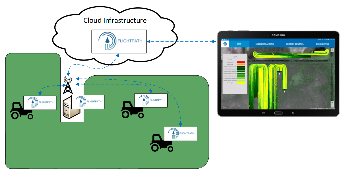
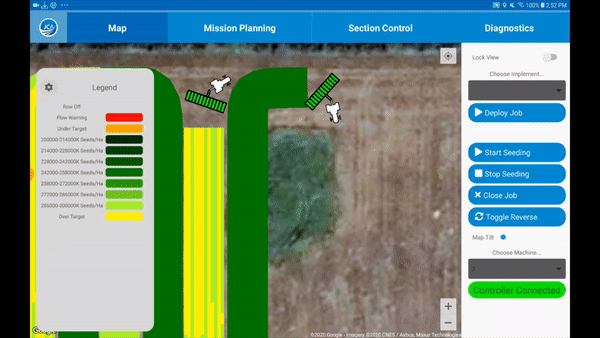
Envision three machines working in the field – these machines could be planting, seeding, spraying, harvesting or tilling. A person with access to any of the FlightPath instances, who could be driving one of the machines or anywhere with a cloud connection, can view coverage, seeding rates or any other data managed by FlightPath in real-time. Below is an actual video recording of what FlightPath is currently capable of doing, displaying seeding rates from multiple machines in real-time.
Multiple Layers
FlightPath can receive and process multiple datasets, called layers, allowing the operator to select what is shown on the fly. Each layer has a configurable scale and allow operators to quickly view progress, monitor job status, as well as detect and react to issues. Examples of typical layers are:
- Coverage
- Seed Rates (Actual and Target/Prescribed)
- Planting Rates (Actual and Target/Prescribed)
- Skips and Doubles
- Spray Rates (Actual and Target/Prescribed)
- Actual Yield
- Driven Path
Other less typical information can be processed by FlightPath as well which may add value to the system and provide a unique way of visualization. For example, fuel consumption rates and instantaneous speeds could be added as layers. At the start of the season, this information along with skips and doubles can be used to determine optimal planting speeds. Alternatively, a harvest application could add unload locations as a layer so that operators can visualize fuel consumption, yield and unload locations to see if there are efficiency improvements that can be made.
Autonomy
Technologies like FlightPath with multiple machine support are a major requirement of the autonomous revolution many are predicting to be coming to agriculture. To increase yields by reducing soil compaction, machines are predicted to be smaller and act more like a swarm increasing the need to efficiently manage them. FlightPath will allow operators to view the real-time status of their machine swarm(s), monitor progress, and react quickly and efficiently to the changing availability of machines as they complete assigned work, get stuck, require maintenance or are repaired.
Other Applications
FlightPath is not limited to agricultural applications. At the core, its premise is to gather and visualize location-based data in real-time. It has been designed to be application aspecific so that JCA can easily develop systems for other applications requiring visualization of location-based data in real-time. Examples of some of these applications include:
- Fleet Management
- Forestry
- Construction
- Public Infrastructure Tasks
- Street Cleaning
- Snow Clearing
Summary
FlightPath has been architected to be a powerful and extremely flexible technology that can be easily integrated into systems. It can be incorporated into systems requiring manual or location based real-time application control, and/or as applied mapping and logging. It can also support single or multiple machine systems with an optional cloud component. If your system could benefit from any of the features FlightPath offers, please contact us at info@jcaelectronics.ca. We’re excited to discuss all opportunities.
About JCA Electronics
With operations in both Canada and the USA, JCA Electronics provides advanced technology solutions for off-highway mobile machines, primarily in agricultural, construction, and mining industries. JCA Electronics’ engineering and manufacturing operations have been providing customized electrical, electronics, and software systems for OEMs since 2002. For more information see www.jcaelectronics.ca or contact us at info@jcaelectronics.ca.